Galapagos Ferry Routes and Sea Conditions Compared
Galapagos Ferry Routes Compared: Santa Cruz to Isabela vs. San Cristobal
When planning an independent island-hopping holiday in the Galapagos Archipelago, understanding the geography of maritime transit is crucial. All public inter-island speedboats utilize Puerto Ayora on Santa Cruz Island as their central logistical hub. This means there are no direct routes connecting San Cristobal and Isabela; every traveler must navigate back to Santa Cruz before transferring to the next destination. However, the most critical piece of information that travelers look for online is how ocean conditions vary across these specific oceanic channels. The ocean behavior is drastically different depending on the route you take, which directly dictates your risk of motion sickness.
The Westward Passage: Santa Cruz ↔ Isabela
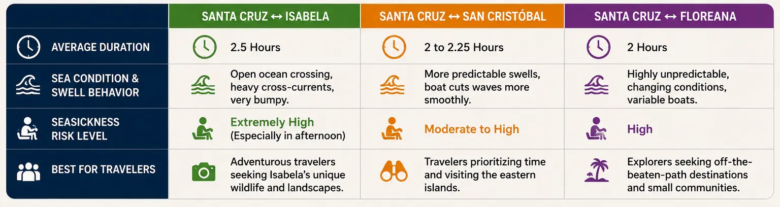
The journey between Puerto Ayora (Santa Cruz) and Puerto Villamil (Isabela) is widely noted by tourists prone to seasickness. This specific path requires the speedboat to navigate directly across open ocean waters, perpendicular to major Pacific swells and dominant underwater currents. Because these lightweight speedboats carry between 20 and 40 passengers, they take the full brunt of the waves. The afternoon crossings on this route are particularly notorious for being choppy and rough, resulting in a bumpy two-and-a-half-hour ride where the boat constantly slams against the sea surface. Travelers are highly advised to review essential seasickness Galapagos ferry tips and take medication before boarding this leg of their journey.
The Eastward Passage: Santa Cruz ↔ San Cristóbal
In contrast, the maritime highway connecting Puerto Ayora with Puerto Baquerizo Moreno (San Cristobal) offers a slightly more predictable navigation experience. While the vessel is still traveling in open ocean, the structural direction of the waves and currents relative to the hull allows the speedboats to cut through the water more efficiently. It is by no means a flat, calm lake ride—you will still experience rolling swells—but the movement is generally smoother and less jarring than the intense pounding experienced on the way to Isabela Island. If you plan to travel this route, checking the specific details for the Santa Cruz to San Cristobal ferry can help you choose the best operator.
The Southern Track: Santa Cruz ↔ Floreana
The lesser-traveled route to Floreana Island is a niche path with fewer daily departures. The maritime conditions here can be treacherous and highly unpredictable. Because demand is lower, the sizes and configurations of the vessels assigned to this route vary considerably, making the experience highly dependent on the specific boat operator you secure on that day.
Galapagos Inter-Island Route Comparison Matrix
Ferry Route
Average Duration
Sea Condition & Swell Behavior
Seasickness Risk Level
Santa Cruz ↔ Isabela
2.5 Hours
Open ocean crossing, heavy cross-currents, very bumpy.
Extremely High (Especially in afternoon)
Santa Cruz ↔ San Cristóbal
2 to 2.25 Hours
More predictable swells, boat cuts waves more smoothly.
Before booking your island-hopping transfers on GalaFerry, review your itinerary and consult a comprehensive galapagos ferries inter island routes and practical info guide to ensure you are physically prepared for the unique oceanic environment of each route. Booking your tickets online ahead of time guarantees a slot on the most modern and stable vessels operating within these challenging waters.