The inter-island boats that link Santa Cruz, San Cristóbal, Isabela and Floreana are enclosed-hull speedboats of roughly 30 passengers, not stabilised ferries. They cross open Pacific water for two to two and a half hours with no keel weight to dampen motion and no capacity to outrun a swell. The result is that sea state, rather than distance, determines whether a crossing feels routine or punishing. The same 96 kilometre run between Puerto Ayora and Puerto Baquerizo Moreno can be glassy in March and genuinely difficult in September.
That variation is not random. It follows a predictable annual cycle driven by the Humboldt Current, the southeast trade winds and long-period swell generated by winter storms in the Southern Ocean. Understanding the cycle allows travellers to schedule island hops around the worst windows rather than discovering them mid-crossing.
Tides complicate the picture in a different way than most visitors expect. The archipelago experiences a semidiurnal regime, with two high and two low tides in roughly 24 hours and 50 minutes, and a spring range approaching two metres at Puerto Ayora. Those tides have limited influence on comfort in open water. Where they matter decisively is at the ports: channel depth at Puerto Villamil, boarding conditions on exposed pier ladders, and the timing of water taxi transfers. Separating the two effects, swell for the crossing and tide for the port, is the key to reading Galápagos ferry conditions accurately.
| Specification / Metric | Detail / Value |
|---|---|
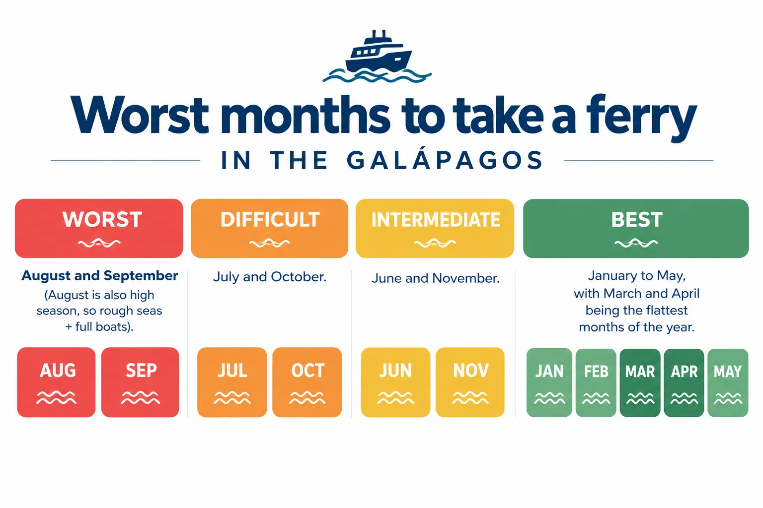
| Roughest crossing window | Late July to early November, with August, September and October the hardest |
| Calmest crossing window | January to May, typically flattest in March and April |
| Dominant driver of rough seas | Southeast trade winds plus south and southwest swell from Southern Hemisphere winter storms |
| Tidal regime | Semidiurnal, two highs and two lows per lunar day |
| Spring tide height, Puerto Ayora | Around 1.9 to 2.0 m at new and full moon; neap range often under 1 m |
| Sea temperature contrast | About 19 to 23 °C in the cool season, 25 to 28 °C in the warm season |
| Standard departures | Morning near 07:00 and afternoon near 14:00 to 15:00 on main routes |
| Most exposed route | Santa Cruz to San Cristóbal, roughly 96 km of open water with no lee shelter |
| Most tide-sensitive port | Puerto Villamil, Isabela, reached through a shallow marked channel among reefs |
| Cancellation frequency | Low overall; delays and afternoon suspensions more common than outright cancellations |
Two currents, two seasons and a sea surface that behaves differently in each
Galápagos sits at the convergence of several major current systems, and its weather divides cleanly into two regimes. From December to May the Intertropical Convergence Zone shifts south, warm water dominates, winds fall light and the sea surface flattens. Crossings in this period are frequently described as unremarkable, which is the highest compliment a speedboat passenger can pay.
From June to November the Humboldt Current strengthens, pushing cool, nutrient-rich water north. Air temperatures drop, a persistent low cloud layer known as the garúa settles over the highlands, and the southeast trade winds intensify. This is excellent news for wildlife, since the nutrient influx drives feeding activity across the archipelago, and poor news for anyone prone to motion sickness. The same upwelling that makes September such a strong month for whales and marine wildlife also produces the year’s most uncomfortable crossings.
Why August, September and October are the months to schedule around
Two independent forces peak together in this window. The trade winds reach their strongest and most sustained phase, generating short, steep wind chop across the channels. Simultaneously, winter storms in the far South Pacific send long-period swell northward, which arrives in Galápagos from the south and southwest after travelling thousands of kilometres. Long-period swell is not necessarily large in height, but it produces deep, rolling motion that a light hull follows entirely.
The combination of wind chop layered over ground swell creates a confused sea, and confused seas are what passengers remember. Complaints and requests for schedule changes cluster heavily in this period, as do afternoon suspensions when a captain judges conditions unsuitable. Travellers who must cross during these months should plan seating and medication deliberately, starting with our guidance on preventing seasickness on Galápagos ferries.
The calm season carries its own caveats
January through May delivers the smoothest water of the year, with March and April typically the flattest. The tradeoff is weather rather than sea state: this is the wet season, with intense but usually brief afternoon downpours, high humidity and occasional visibility reduction. Rain alone rarely stops a crossing, though it soaks any luggage stowed on the stern deck or roof rack.
Interannual variability adds a further layer. During El Niño phases, water warms unusually and swell patterns can weaken, but rainfall increases sharply and storm activity rises. La Niña conditions do the reverse, reinforcing the trades and cooling the water, which extends the rough window and can make a normally moderate June or July feel like peak garúa season. Neither phase overrides the basic seasonal pattern, but both shift its intensity.
What the tides actually control, and what they do not
Tidal range at Puerto Ayora peaks near two metres on spring tides, when the moon is new or full, and can fall below one metre on neaps at the quarter moons. In open water between islands, this has almost no bearing on passenger comfort. Wind and swell dominate by a wide margin, and any claim that a crossing will be smooth because of a particular tide should be treated sceptically.
At the ports, the influence is real. Puerto Villamil on Isabela is the clearest case: the harbour is reached through a narrow marked channel threading reefs and mangrove shallows, and at low water captains slow substantially and follow the channel precisely. Anchorages shift, water taxi routes lengthen and boarding takes longer. Floreana’s Puerto Velasco Ibarra, served far less frequently than the main ports, presents similar constraints at a smaller scale. These conditions are among the reasons the Santa Cruz to Isabela crossing runs to fixed daily slots rather than flexible departures.
Boarding itself is tide-dependent everywhere. Passengers transfer to anchored speedboats by water taxi, and at low tide the step down from a pier ladder to a moving launch is considerably larger. Travellers with limited mobility or heavy luggage feel this immediately.
Spring tides, channel currents and the daily wind cycle
Spring tides amplify tidal currents through the channels between islands, and where a strong ebb current runs against an incoming swell, the sea steepens locally. This is a well-documented interaction in any archipelago and explains why certain stretches of a familiar route feel abruptly worse for fifteen or twenty minutes before settling.
The more reliable daily pattern is thermal. Winds are typically lightest at dawn and build through the day as the land heats, which is why the morning departure near 07:00 is usually calmer than the afternoon sailing. During the rough season the difference can be substantial, and experienced travellers book morning crossings almost exclusively. Seat position compounds the effect, as explained in our guide to choosing the best seats on the ferry.
Crowding as the second kind of bad timing
Sea state is only half the question. Mid-June through August and mid-December through mid-January are the archipelago’s peak visitor periods, joined by Carnival in February and Semana Santa in March or April, when Ecuadorian domestic travel surges. During these weeks boats sell out days in advance, and a cancelled or missed sailing can strand an itinerary rather than merely delay it.
August is therefore doubly awkward: rough seas coinciding with maximum demand. Travellers with flexible dates often find that late April, May and November offer the best balance of moderate seas, moderate crowds and full route availability. Monthly patterns are compared in detail in our monthly ranking of when to visit Galápagos, and route alternatives including inter-island flights are set out in our overview of how to travel between the Galápagos islands.
Final Thoughts
The seasonal roughness of Galápagos crossings is a direct consequence of the archipelago’s position at a major oceanographic junction. The Humboldt Current that makes these waters biologically extraordinary is the same mechanism that stiffens the trade winds and unsettles the sea from July onward. There is no version of the Galápagos in which the ecological richness and the navigational calm coincide, and visitors are effectively choosing between comfortable water and peak marine activity.
The tidal question deserves more precision than it usually receives in travel discussion. Tides in the archipelago are moderate by global standards and largely irrelevant to open-water motion, yet they govern harbour access at Isabela and Floreana with considerable authority, and they shape the fixed departure structure that visitors often mistake for administrative convenience. Recognising which variable is doing the work prevents both false reassurance and unnecessary anxiety.
For practical planning, the useful conclusion is narrow and reliable. Choose morning departures over afternoon ones, favour the shoulder months of late April, May and November when itineraries allow, build at least one buffer day into any schedule that ends with an international flight, and treat August through October as a period requiring preparation rather than avoidance. The crossings continue to operate through the rough season, and they operate safely. What changes is how much the passenger notices.
Rough Seas and Tides on Galápagos Ferries (FAQ)
Which month has the roughest Galápagos ferry crossings?
August and September are consistently the most difficult, with the broader rough window extending from late July into early November. During these months the southeast trade winds reach maximum strength while long-period swell generated by Southern Hemisphere winter storms arrives from the south and southwest. The two combine into a confused sea that light speedboat hulls follow closely, producing the pitching and rolling that passengers report most often.
Are Galápagos ferries ever cancelled because of the sea?
Outright cancellations are uncommon, since these vessels are built for the conditions and crews cross the same routes year round. Delays and occasional afternoon suspensions are more frequent, particularly during the garúa season when wind builds through the day. Because captains make that call close to departure, travellers should avoid scheduling an inter-island crossing on the same day as an international flight from Baltra or San Cristóbal.
Do tides make the crossing between islands rougher?
Not significantly in open water. Wind and swell dominate passenger comfort by a wide margin, and the archipelago’s tidal range of roughly two metres on spring tides is moderate. Tidal currents can steepen the sea locally where an ebb runs against incoming swell, usually for short stretches. The genuine tidal effects are at the ports, where water level governs channel navigation, anchorage position and how far you step down to a water taxi.
Why is arrival at Puerto Villamil on Isabela slower at low tide?
Puerto Villamil is approached through a narrow marked channel that threads between reefs and mangrove shallows. At low water the usable depth narrows and captains reduce speed to follow the channel precisely. Anchorage positions shift further out, water taxi runs lengthen, and disembarkation takes longer than at Puerto Ayora or Puerto Baquerizo Moreno. This is one reason the route runs on fixed daily departure slots.
Is the morning ferry calmer than the afternoon one?
Usually yes. Winds are lightest around dawn and strengthen through the day as land surfaces heat and drive local circulation, so the departure near 07:00 generally encounters a flatter sea than the sailing near 14:00 or 15:00. The difference is most pronounced between July and October, when experienced travellers book morning crossings almost exclusively and treat the afternoon slot as a fallback rather than a first choice.
What are the best months to island hop by ferry with moderate crowds?
Late April, May and November tend to offer the most workable balance. Seas are moderating or still settled, all routes operate on full schedules, and visitor numbers fall between the June to August peak and the mid-December to mid-January surge. February’s Carnival and the Semana Santa week in March or April bring short bursts of heavy Ecuadorian domestic travel, so booking several days ahead remains advisable even outside the main international season.